Palos Verdes Real Estate
Home"Palos Verdes Resident since 1947"
Around the Hill in 80 Minutes
Around the Hill in 80 Minutes – Apologies to Jules Verne – A Self-Guided Driving Tour. By Dana Graham
AROUND THE HILL IN 80 MINUTES – APOLOGIES TO JULES VERNE-A SELF-GUIDED DRIVING TOUR
By Dana Graham
The scenic Palos Verdes Peninsula, apart from hikers and bikers, is a favorite drive primarily for the scenery. But you may be driving past a lot of the history. So next time you are on quarantine and want to take a drive, take this with you and you will find new things to appreciate about Palos Verdes. So here we go – up, up, and away!


Malaga Cove Plaza

We begin in Malaga Cove Plaza in Palos Verdes Estates. This was the first “shopping center” on the Hill. The white building on the west end was the first structure build in 1924 and is known as the Gardner Building. This initially housed all administrative functions of the Palos Verdes Project, as it was called in the pre-City days. In 1928 the Syndicate Building on the opposite end (used red brick with the arch) was built, which houses offices for private businesses as well as a playhouse. The fountain in the center of the Plaza was added in 1930 and is a 3/5 replica of one in Bologna, Italy.
Chaplin House
From here, go down Via Almar, which is the cross street at the west end of the Plaza. Immediately after the first stop sign on the left you will see a rambling old Spanish house built in 1930. It is rumored to have been built by Charlie Chaplin to house his mistress, out of sight and mind of his wife.

Malaga Cove School
As you round the bend, Malaga Cove School will come into view on the right. This was the first school on the Hill, completed in 1925, and housed kindergarten thru 8th grade. Prior to 1961, you went off the Hill for high school. Turn right at the stop sign at the far end of the school, then left at the next stop sign.

Neighborhood Church
On your right will be Haggerty’s, the famous surfing spot the Beach Boys sang about. It is named for the J J Haggarty (not sure how the spelling changed) mansion immediately adjacent, which now houses the Neighborhood Church. Haggarty built the place in 1928 as a weekend retreat at the then-astronomical cost of $750,000. A 15,000 square foot Spanish Revival villa with a 6 car garage, 4 bedrooms, 3.5 bathrooms, 2 waterfalls, a pool, and a partridge in a pear tree, it was completed in 10 months. It was never lived in, went thru several owners after Haggarty was forced to sell it in 1931 (timing is everything) and was acquired by Neighborhood Church in 1950. There are several more complete histories of the church on YouTube or on my website: www.DanaGraham.com.
Continue past the church and the road curves left and goes up to a bluff overlooking appropriately named Bluff Cove, another famous surfing spot. In my surfing days (late ‘50’s, early ‘60’s) you had to be pretty good to surf at Haggerty’s and Bluff Cove because you couldn’t tie the 10’ boards of the day to your ankle like they do with the little ones today; so if you wiped out on a wave and lost your board, it would end up being damaged on the rocks.
When you’re done fantasizing about hanging 10, continue up the hill and bear left. The next stop sign will be Palos Verdes Drive West. Turn right (you can’t turn left . . . well, you could . . . I know a good body shop). Continue on PV Drive West and bear right the first chance you get (you will now be back on Paseo Del Mar) then left at the first opportunity, then bear right onto Chelsea Rd. You will soon come to 1501 Chelsea Rd, which was the home of Ethel Barrymore, the the original has been rebuilt.

Barrymore House

Barrymore House
Continue on Chelsea and you will run into Palos Verdes High School. Originally planned as a Jr Hi when we were part of the LA School District, the property was acquired by the Palos Verdes School District when it came into being in 1959. PV High opened in the Fall of 1961. Interestingly enough, the architect was Richard Neutra.
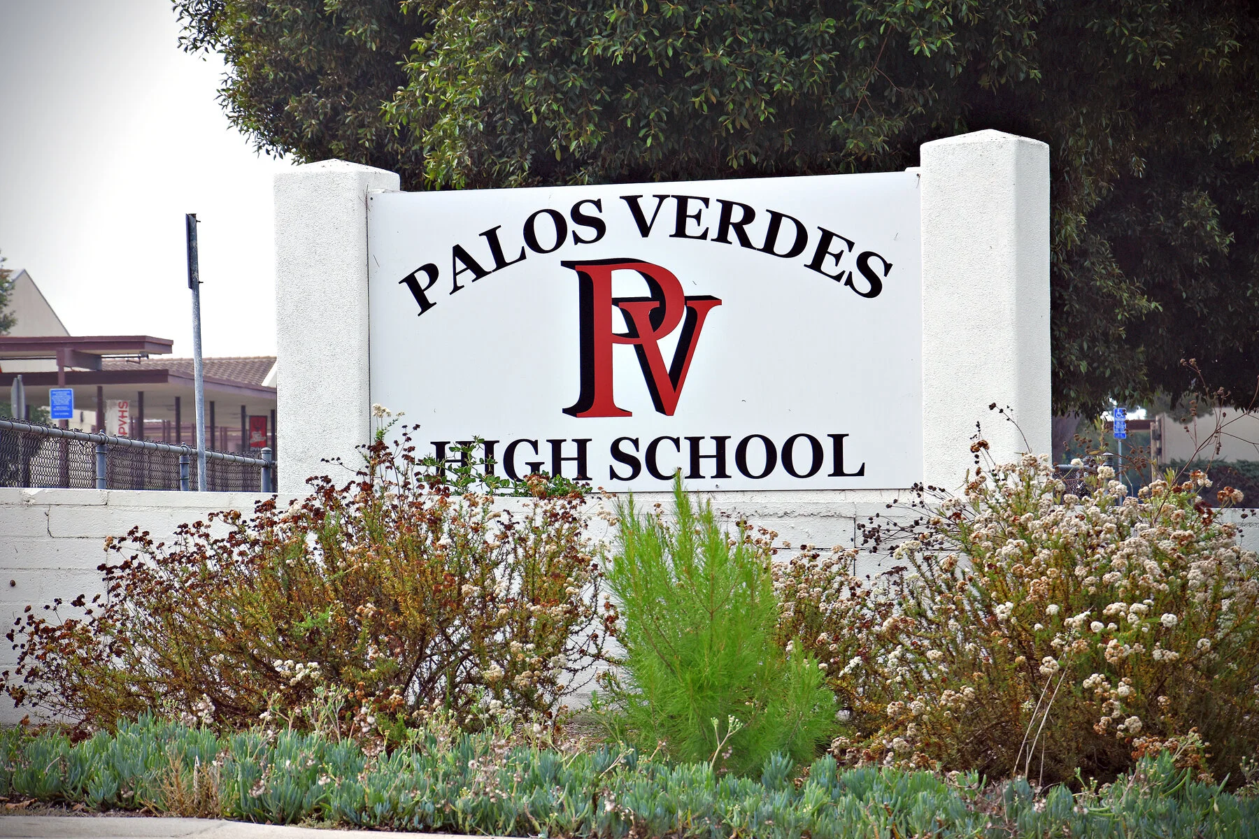
PV High School
Go toward the ocean on Cloyden Rd (which Chelsea intersects) and turn left on Paseo Del Mar. Up until the mid 1960’s, believe it or not, this section of Paseo Del Mar was still a dirt street with no houses on it. Your first right is Rocky Point Rd. Rocky Point, tho hardly anyone remembers it now, was one of the first housing tracts in Palos Verdes, having been built between 1956 and 1960. It is now extremely valuable real estate and few of the original homes still exist, tho if you drive around you may spot a couple of them – typical 2000 sf late ‘50’s ranch style homes. It was on these rocky shores that the Greek freighter Dominator (originally US Victory Ship Melville Jacoby) famously ran aground on a foggy night in March, 1961

Rocky Point

Point Vicente Interpretive Center
Take your first right after you curve thru Rocky Point and then right again on Paseo Del Mar, and follow this all the way back up to PV Drive West. You will be passing famous surfing spot Lunada Bay on your right, tho you have to get out at the parkland to see it. Your first light on PV Drive West will be at Hawthorne Bl/Golden Cove. Keep going straight and on your right you will see the Palos Verdes Interpretive Center down near the ocean. This was the site of a firing range operated by the Coast Guard until about the mid-1970’s. When I was in the Marines, this is where we qualified with the M14 rifle. Just south of that is the historic Pt Vicente Lighthouse, built in 1926. This was the lighthouse the captain of the Dominator was looking for when he turned to port prematurely.

Point Vicente Lighthouse
Continue on and just over the next rise Terranea will come into view. This is the former site of Marineland Oceanarium which operated from 1954 until 1987 – pre-dating Disneyland and Sea World. Terranea bought the property, built the spectacular resort you see, and opened in 2008, right into the Great Recession. A combination of savvy management and cooperation from the City of Rancho Palos Verdes allowed them to survive that, and they are now thriving. If you find yourself here at lunchtime, they have several good restaurants with reasonable prices, considering. Don’t be drinking tho, because the road gets pretty exciting just around the next bend.

Terrenea
Exit Terranea and turn right. Just over the next rise on the left will appear world famous Wayfarer’s Chapel, designed by Frank Lloyd Wright, Jr, and opened in 1951. The denomination is Swedenborgian (you can Google Emmanuel Swedenborg) of which Elin Vanderlip, who donated the land, was an adherent. Everyone called it the Glass Church back in the day, for obvious reasons. Many famous people have chosen to be married there, Jayne Mansfield among them.
Continue on and the road soon becomes an E-ticket ride. The famous Portuguese Bend Landslide began in late 1955 when grading for the extension of Crenshaw Blvd to PV Drive South began. It was determined that enough dirt was moved to set a dormant, ancient landslide in motion. Under it all is about a 3’ thick layer of bentonite clay, which is like Teflon when wet, so rain and septic systems on the hillside above (can’t have sewers because the land is moving) keep it periodically lubricated and moving.


Seaview Estates
Assuming you survive this bumpy ride, the road smooths out at the Portuguese Bend Club on the right, and Seaview Estates on the left. I recently discovered that what is now known as Seaview Estates was originally known as Portuguese Bend Estates when it was built between 1956 and 1960. The architect was the now-famous Paul Williams.

Racing
Keep a sharp eye out on the left for the turn onto Palos Verdes Drive East, which you will see winding up the hill. This has been a popular racing spot for kids from my youth thru present, as you might imagine. As you get to the top of the hill you will find on your right Marymount Palos Verdes College. As you continue on you will see spectacular views of San Pedro and the Los Angeles Harbor. This area of Palos Verdes is known as Miraleste (view to the east).
Shortly there will be a wide spot in the road where Miraleste Drive intersects. Now that you’ve made it past the slide, feel free to visit Miraleste Liquor store and get gas if you need it.. This area is one of the earlier areas settled on the Hill, the first houses having been built in the 1930’s when it was under the auspices of the Palos Verdes Project. Design and building of homes in Miraleste is still under the control of the Palos Verdes Art Jury today.

Dapplegray
Continue on PV Drive East until you come to the traffic light at PV Drive North. Get in the left turn lane. On your right, you will see a reservoir now obscured by trees, which used to hold the water supply for San Pedro, but is only intermittently used today. Turn left and you should now be going west and have just entered the City of Rolling Hills Estates. On your right is some of the most desirable horse property on the Hill, known as The Lanes (Dapplegray, Strawberry, etc), and you are likely to see horses being ridden along the Drive. Just past the lanes you will see on the right Dapplegray Elementary School (everything over here is named for horses), which opened in the mid-1950’s as a Jr High.

Just past the school the road rises to a traffic light. On your left is the main gate to the exclusive City of Rolling Hills, founded by A E Hanson in the1930’s as an equestrian enclave. When I was a kid in the 1950’s pretty much everyone in the Lanes and Rolling Hills had horses; not so much now. On your right is Kelly’s Corner, known for decades as the Rolling Hills General Store. In the 1950’s, when there were no supermarkets on the Hill, we used to actually come over here to shop.

Since the guard probably won’t let you into Rolling Hills, continue straight ahead. Just before you get to Crenshaw Blvd you will see a sign on the left that says “Westfield”. When most of the Hill was unincorporated L A County a few intrepid property owners began building in this area. When Rolling Hills Estates was incorporated as a city in 1957, Westfield voted to remain independent and is technically L A County today, tho many residents use RHE as an address. You’re going to turn left on Crenshaw Blvd, so get into the left turn lane
When you get to the light at Crenshaw Blvd and look over to the right, that whole area on both sides of Crenshaw was the Great Lakes Carbon diatomaceous earth mine (dicholite to you and me). It ran from just west of Rolling Hills Road all the way over to what is now Hawthorne Blvd. When the mine closed just after World War 2, it became a County landfill. In the 1950’s there was no trash pick-up in PV, so that’s where we took our trash – it was a huge canyon in those days.
Drive up Crenshaw Blvd and turn right at the first light (you can’t turn left) – called Silver Spur Road. After 50 or so yards you will see a small shopping center with a CVS drugstore. This is roughly where the prison used to be. Yes, I kid you not, there was a minimum security prison there until 1956. Why 1956? Remember the landslide you drove thru on PV Drive South? There was a plan to put Crenshaw Blvd down the back side of the Hill to connect with PV Drive South and the prisoners were working on it; but in late 1955 there began to be land movement and it was determined at the time that grading for the Crenshaw extension had disturbed an ancient landslide that had been at equilibrium, thus setting in motion the now famous Portuguese Bend Landslide. The prison was closed and the rest is history.
While you’re sitting there, you should know that there was once a seasonal lake there. If you look around and imagine a time before Crenshaw had been cut thru, you can see that water had no outlet and would congregate there every winter.
Continue driving up Silver Spur. If you’re hungry, there is an excellent and very famous Mexican restaurant on your right – the original Red Onion, which has been there since 1961. As you approach Hawthorne Blvd (get in the left lane), on your left will be the original Peninsula Center, built in 1961 and the first real shopping center on the Hill. As you sit at that light, diagonally across the street is Peninsula High School, opened in 1964 as Rolling Hills High.
At this point you may wonder how the schools got such choice locations. Turns out that the Palos Verdes Project in the 1920’s realized that the community would need schools and so deeded gratis to the district sites for elementary, junior high, and high schools, the only stipulation being that they could not be sold off or used for purposes other than education. Most of these sites were in the hinterlands in those days.

Turn left onto Hawthorne Blvd and proceed up a gentle hill to Highridge Rd and turn left (it’s Grayslake if you turn right, but don’t). You wind up a little hill and come to a stop sign at Armaga Spring Rd, where you will see a development called Wallace Ranch. This is named after famous (if you’re into shortwave radio) shortwave operator Don Wallace, who had an “antenna farm” on this flat area, almost down to Crest Rd, from just after WW 2 until the early 1970’s. During WW 2 it was owned by the US Navy Dept, who used the antennae as a relay station between Washington DC and the South Pacific. It was through this station that the Marines communicated following their invasion of Guadalcanal August 7, 1942. I’d like to say that notice of the Pearl Harbor attack also went thru this relay station, but it actually went thru a similar one in San Francisco, tho these guys must have picked it up – “AIR RAID PEARL HARBOR — THIS IS NOT DRILL”.
Proceed on down Highridge Road and you will run into Crest Road. On the ocean side of Crest was the famous ranch run by the McCarrell family from the early 1950’s thru 1972, when the land was sold to developers who built the housing developments of Island View and Ocean Terrace, which you now see there. The McCarrell family is still around the area, and Rosalee McCarrell is the last living link from that family’s Peninsula farming activities which began in the 1910’s.
Turn right on Crest Road and proceed down to Hawthorne and turn right. On your left will soon appear Hesse Park, name after one Fred Hesse who was not only one of my dad’s tennis partners, but was one of the founders of Rancho Palos Verdes. Continue on past the light and turn left at the next one (7-11 on corner). You are now on Granvia Altamira which runs thru the lots that were selling for $500 each in 1950 when my father was advised to buy a few. Apart from the fact that my parents didn’t have an extra $500 lying around, this was barren land in those days with no roads whatsoever – no Granvia Altamira or anything else. By this close brush with history, my inheritance was thus seriously attenuated.
The second stop sign you reach will be Cataluna Place. Look to the right and it goes up into a little draw (drive up there if you want), which was the end of civilization back in the 1920’s. It was in this location that the barn and repair facilities for the trolley cars that were planned to run throughout Palos Verdes Estates were to be located. By the mid 60’s all hopes of the tracks and cars going in had disappeared, and a builder built the tract of homes you see there now.


Continue on down Granvia Altamira. When you get to 1133 Granvia Altamira on the left, notice the right of way going down into that little gulley — there is now a gray fence across it. This is one vestige of the trolley that is still visible. If you look to your right at 1136 you will see a newer house built on narrow frontage lot.This is one vestige of the trolley that is still visible. If you look to your right you will see a newer house built on narrow frontage lot. This was actually where the tracks crossed the street and when that easement was abandoned, a lot was created and a house squeezed onto it. That right of way, by the way, continues along the east border of PVE between it and RPV.
OK, before the guy calls the cops, keep going down Granvia to where it turns right and there is a park in front of you. The original plan for PVE called for various small shopping centers in each of the areas, and this was the one for Montemalaga. They are generally parks now, except for the one in Lunada Bay, which did become a shopping center.
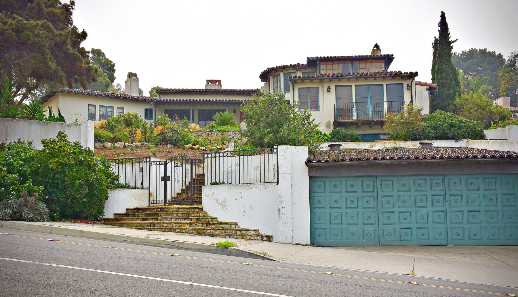
Turn left at the stop sign and you’re going down Via Del Monte. At the first stop sign you come to, that’s 881 Via Del Monte across the intersection to the left. Built about 1930, this was one of the first houses in PVE and is visible in a lot of the early photos. This house actually had horse stables on the property, which was legal before the War.


When you come to the next stop sign, on your right is La Venta Inn at 796 Via Del Monte. This was the original real estate office for the Palos Verdes Project and actually was a small functioning inn where people coming from the West Adams area and that new development called Beverly Hills could stay overnight while looking at vacant lots in PV. If you think PV is remote today, it was really a trek in the 1920’s and ‘30’s. The view is spectacular and it is a favorite spot for weddings and other special events. Today it is owned by a private family and is leased to the New York Food Company which, once the hysteria over Covid dies down, will probably fire it back up again.
Keep going down around the hairpin turn and after the next stop sign the road turns to the left. Just after you turn you will see 657 Via Del Monte on the left – the one with a wall in front. This was originally the home of PVE founder Charles Cheney and is also visible in many of the early pictures sitting there all by itself.
Continue on down Via Del Monte to the next stop sign (the street levels out) and on your right is the original Palos Verdes Library, built in 1930 and designed by famous architect Myron Hunt. It was a social center for the early PV residents and even up into the 1950’s when PV resident Charles Laughton would read Shakespeare on the lawn and my parents would make us kids go listen.
Turn left at that stop sign and right at the next and you will find yourself back at your starting point – Malaga Cove Plaza. I hope you’ve enjoyed this little self-guided tour of PV.
Photography credit: Simie Seaman

Dana Graham, Realtor®
Berkshire Hathaway Home Services
CA DRE #00877973
310 265-2141 (direct)
310 613-1076 (cell)
Top 10 agent
in PV in listings sold