The Dicalite Mine
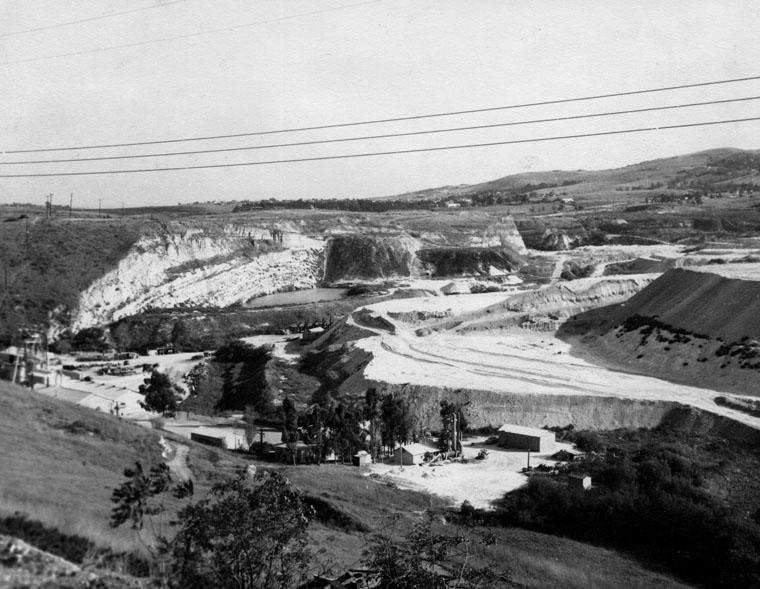
When you’re sitting at the light at Newton going south on Hawthorne Blvd, you can’t miss the large escarpment directly in front of you. Landslide, right? Nope. Up thru WW 2, and long before Hawthorne was extended, there was a diatomaceous earth (dicalite) mine there, which occupied the area immediately north of that escarpment, where Hillside Village is now, and extending around to the area between what is now Rolling Hills Rd and Hawthorne. We used to dig for shark’s teeth there when I was a kid. I told you some of it was ancient history.
Hawthorne Blvd
Hawthorne Blvd moved! Up until 1965 Hawthorne Blvd simply curved to the right across the current site of Hillside Chevron, and what is now Via Valmonte was simply the continuation of Hawthorne Blvd (Avenue within PVE), ending at the PV Golf Course like it does now. Hawthorne in its current form was put thru in early 1965 to connect to the section already in from PV Drive North to the new Peninsula Shopping Center, obliterating the last remains of the dicalite mine, and upsetting the residents of Hawthorne Avenue, who had to change their addresses to “Via Valmonte”. We lived on Pleasant Hill Drive just around the corner and I watched all this go on.
The Landslide
Everyone is familiar with the Portuguese Bend landslide, but did you ever wonder about its history? In 1955 the County (and it was county, as RHE and RPV didn’t exist yet) was planning to extend Crenshaw Blvd from PCH where it ended, up over the Hill and down to PV Drive South. They got past PV Drive North OK and up to Crest Rd, but in the grading process beyond that, enough dirt was removed/relocated that an ancient landslide that had been at equilibrium was set in motion. Turned out that in between the topsoil and bedrock was this pesky 3 feet of bentonite clay, the closest thing in nature to Teflon.
The Portuguese Bend slide has been doing so ever since, also setting in motion the Klondike Canyon and Flying Triangle slides, which have now all slid together. The entire thing slides in an arch, from very little movement on the south end to more movement over toward Wayfarer’s Chapel, where it ends (leading some to speculate about divine intervention). Every time it rains, it lubricates the whole shebang.
When driving thru the slide, if you look up the hill it looks quite different than it did in 1955, when it was a gentle upslope basically all the way to the top, and covered with Japanese-owned truck farms. It has now slid out and dropped down, and even Annie Ishibashi is gone. By the way, the disintegration of the Visitor’s Center of Wayfayer’s Chapel 10 or 12 years ago was a localized problem not connected to the slide.
Palos Verdes State College
The “University Section”: northwest of the intersection of Via Zurita and Via Fernandez (where the Little League field is), this area was once zoned for a university, which is why it’s known as the “University Section”. Prior to the late ’50s there was Palos Verdes College on the site of what was, until recently, La Cresta Elementary School, just inside the Rolling Hills Crest gate. That closed in 1952 and was unrelated.
In 1959 there was a referendum that had two major issues on it: (1) do we approve a State college in PVE located northwest of Via Zurita and Via Fernandez, and (2) do we approve the unification of the Palos Verdes School District. The former was voted down and it became Cal State Dominguez Hills. The fact that it was even considered does tell you something about how the community has changed.
From the perspective of a small kid, that area seemed like the end of the earth, and had no houses within sight. What is now Via Coronel was put in until the early 1970s, and the current Via Zurita was named Via Coronel. The unification of the school district, rather famously, was approved after many unsuccessful attempts during the 1950s, creating the Palos Verdes Unified School District.
The Botanic Garden (aka The Dump)
The South Coast Botanic Garden is lovely, right? Verdant, idyllic, birds singing, trees barking . . . it was The Dump! Up until the late 1950s the area between what is now Hawthorne Blvd and Rolling Hills Road (not all of it, but including the area where Crenshaw Blvd is now) was a large landfill.
We used to take our ’54 Ford station wagon over there and dump our trash, there was no trash pick-up in PV at that time. There was what seemed to a 6 year old kid a long narrow road cut into the side of what was then a canyon, and we would wind down to the bottom to unload our trash. My dad had it down to a science: he’d put everything on a slick tarp and when we were in the right spot in the dump, he’d lower the tailgate of the Ford wagon and hit the gas on the mighty Ford V8, and out would slide the trash.
The later stability and methane problems associated with that area came as no surprise. I mean, if you saw our trash . . .
Via Pinzon
On a personal note, my parents built our first house at 4205 Via Pinzon in 1950 when Via Pinzon was a dirt street. The City would not issue an occupancy permit for a house on a dirt street, so my father and Bob Norman, who had just built 4204, got together and hired a paving company to pave Via Pinzon from Hawthorne Ave (Via Valmonte after 1965, see paragraph above) to meet the existing pavement at Via Paro.
Most streets in Valmonte have curbs. My dad and Mr Norman couldn’t afford curbs, no one was demanding them, and no one on Via Pinzon has since found it necessary to put them in.
By the way, Via Pinzon was named after the captains of 2 of Christopher Columbus’ ships, Vicente and Martin Pinzon, captains of the Nina and the Pinta, respectively.
The Dominator
This one’s pretty recent, but here’s the story. In March 1961 a converted WW 2 Liberty Ship SS Melville Jacoby, now the Greek flag freighter Dominator (no, there was no sister ship named Dominatrix) was conveying a load of grain to LA Harbor on a foggy night. Not only was the crew Greek, but so apparently was the navigation equipment (at least to them).
They made a hard turn to port at what they estimated to be the entrance to the Harbor and ran smack into Rocky Point. Several of my friends lived on newly-developed Rocky Point at the time, and were awakened in the middle of the night by the grinding sound. The ship looked huge as it wallowed there on the rocks, you could almost have waded out to it at low tide. It became a bigger tourist attraction than Marineland. After a few weeks, the grain began to ferment, with the distinct aroma wafting across Lower Lunada Bay.
Palos Verdes High School
Palos Verdes High School was originally planned as a Junior High. Prior to unification of the Palos Verdes School district in 1959, when the schools were part of the LA Unified School District, construction had begun on a new junior high in that location. When the district separated from LAUSD, it was converted to Palos Verdes High School and opened in 1961. I entered as a freshman in 1962.
A bit of trivia: do you know who the architect was? Richard Neutra!
Don Wallace’s Antenna Farm
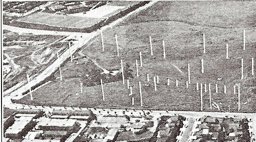
Palos Verdes played a little-known role in the opening campaigns of WW 2. The large flat area northwest of the intersection of Crest and Highridge Roads, and extending almost over to Armaga Springs Road, was owned by the Navy Department prior to and during WW 2, and housed long-wave antennas on telephone poles.
In the early days of offensive operations in the Pacific (the invasion of Guadalcanal in August 1942), the War Department used this site to communicate over long distances (relayed thru Pearl Harbor) to exchange messages with the 1st Marine Division during their tenuous hold on the beachhead while trying to capture Henderson Field.
After the War, a ham radio operator named Don Wallace bought the property, known then as an “antenna farm”. When I was in high school that whole area was covered with telephone poles.
The 4th High School
After the war, and Guadalcanal and the rest of the Pacific was secure, the site of Wallace’s antenna farm was zoned for a 4th high school. However, in the ’70s the demographics of the Hill began to change (not enough people with school age kids could afford to live here), and the site was sold off. It now contains the housing developments known as The Ranch, Rolling Hills Park Estates, and Wallace Ranch, named after Don Wallace.
Why Are Those Streets Blocked Off North of Via La Selva?
In 1946 construction began on the first of several housing tracts in the upper Riviera. By far the best access to that area at that time was thru Palos Verdes Estates, streets like Vista Montana didn’t exist. As a result, all the heavy construction equipment (dump trucks, graders, back-hoes, etc) were rumbling up Hawthorne Blvd (now Via Valmonte), down the Drive, and up and down Via La Selva.
It didn’t take long for residents to tire of this, apart from the obvious danger to us baby boomers riding around on our tricycles. About 1948 the residents (my parents among them) prevailed upon the City of PVE to install those steel posts across Via Alameda, Via Pasqual, and Via Colusa just inside the PVE city limits, and they’ve been there ever since.
The Prison in Palos Verdes
Did you know that there was once a prison where the Peninsula Center is now? It wasn’t exactly San Quentin, and I’m not sure when it opened, but there was an “honor farm” until about the mid-’50s, roughly where Bristol Farms/CVS Drugs are now, and the prisoners worked on the extension of Crenshaw Blvd.
This was before “The Slide”, and going up newly built Silver Spur Rd, curving on up to Crest, turning left “behind The Gates”, and going down Portuguese Bend Rd (which connected to Narcissa Drive until the late 1950s when the slide destroyed it) was the most direct route from Valmonte to Portuguese Bend and my sister’s piano lessons (!). We used to pass the “prison” every week.
Of course, it was that work on Crenshaw Blvd that was thought at the time to be the proximate cause of the Slide (see The Landslide above).
Light Rail in Palos Verdes
Say what? No, this is not some new scheme to bring light rail to Palos Verdes. Actually, it was in the original plan for the City. Everyone is familiar with the Red Cars that ran from downtown LA to San Pedro up until the early 1950s (my father used to ride them to work and back), but Palos Verdes was once slated to have its own system. Like some other of the original ideas, it ran afoul of the Great Depression.
The original idea was to have a system of light rail throughout the City for commuting, shopping and, I suppose, general convenience. If you’ve lived here for any period of time, you’ve no doubt noticed the easements, alleys, and strange rights-of-way running behind lots, across streets, and winding around the City of PVE.
One of them runs behind Granvia Altamira between PVE and what became RPV, curving out across Granvia between Via Sonoma and Novato Place, then running behind the homes on the west side of the street, crossing Via Fernandez to arrive at the planned-but-never-built Montemalaga Plaza (now a park). Another runs behind Paseo Del Mar from the 1500 block out to Paseo Lunado.
Finding these old rights of way is a little like trying to find the original Route 66, as much of it has been deeded to adjoining lots or other purposes: on the east side of Granvia where it curves out to cross the street just up from Novato Place, that right of way has been converted to a lot, sold, and a house now sits on it. But look across the street and you will see the right of way continue down that little draw behind the homes in the 1100 block across the street.
I’m pretty sure it was also supposed to run down the middle of PV Drive North in Valmonte, tho where it was supposed to go once it got to the end and Via Alameda is not clear. Anyway, these are remnants of the once-planned light rail line for Palos Verdes.
Another related anomaly is Cataluna Place in Montemalaga. You will notice that it runs up into a little draw which, at the inception of the Palos Verdes Project, was pretty much at the edge of civilization. This was good because it was planned as the “yard” for the streetcars, barns for repair, storage, etc. By the 1960s it was clear that the rail line was never going to happen, and a developer built the homes on Cataluna Place.
The Nike Missile Base
I suppose it’s obvious to anyone visiting Rancho Palos Verdes City Hall that this facility originally served another purpose . . . it was a Nike missile base during the Cold War. The Nike was a surface-to-air missile intended to shoot down incoming bombers and the West Coast was dotted with launch facilities.
I remember taking a field trip (remember those?) to the base in 4th grade (that would be 1958) and peering down into the silos at the missile menacingly staring back. This, of course, explains why the two-story buildings have the look of military barracks, that, in fact, is what they were, for the garrison based there.
Once ICBMs were sufficiently developed, the Nike became obsolete, along with the launch sites, and when RPV incorporated in 1973 and needed a City Hall, the old base was, in current jargon, re-purposed.
Neighborhood Church
Neighborhood Church is a favorite wedding spot and kind of a landmark. My parents began attending there in 1947, when services were held in the old Malaga Cove School auditorium.
J J Haggarty had owned a chain of women’s clothing stores from just before WW 1 until the Depression, and had built a 15,000 square foot Italian Renaissance mansion on the bluff as a weekend retreat. Unfortunately his [evidently high-maintenance] wife Bertha never liked the place, and his business retreated during the Depression more than he did, finally going belly up. He was forced to sell it in 1931.

During the Depression and WW 2 it passed thru a few hands and, by 1950 had been on the market for a couple of years, starting at $750,000 but recently reduced to $250,000 (I don’t want to hear any more complaints about price reductions). By this time it was a major “cosmetic fixer” with everything from wild animals to homeless people (they were hobos then) living in it.
The Church faithful (my parents among them) had had their eye on it and managed to scrape together $60,000 as a downpayment. To everyone’s surprise, the owners took that as payment in full. I was old enough to remember the trauma when, having bought the property, the City then said they would not allow it to be used as a church. Just great, what now?
Turned out that Dennis Smith (more about him later), an original member of the PVE City Council and one of the major contributors to our buying the property, twisted some arms and, along with my father, orchestrated a campaign in the Palos Verdes News to make the City look cruel and heartless. In early 1952 the City relented, and we moved in.
Those early days were exciting for two little kids (my sister Lucinda and I), our mom was the Church organist and practiced there on Thursday afternoons on the mighty Hammond electric, leaving Cinda and I to explore the place. When the Church took ownership in 1951 the minister, Rev Richard A Dawson, lived on the property, and homeless people were still wandering in and out.
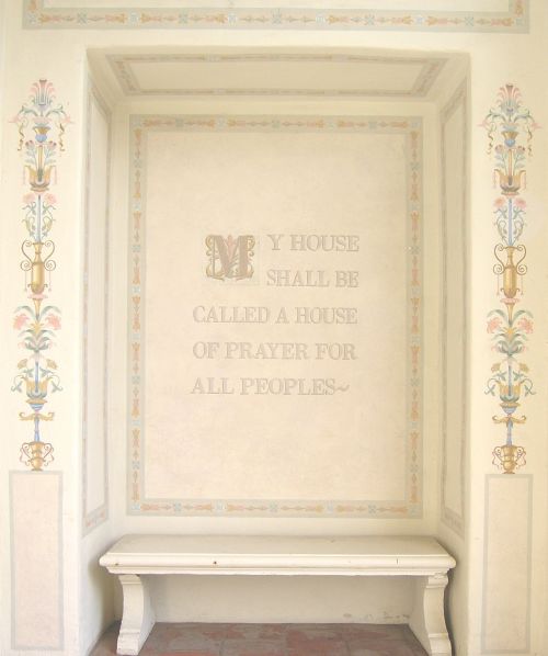
My father was a professional graphic artist and in 1952 Rev Dawson asked him to paint the words “My House Shall Be Called a House of Prayer for All Peoples” just to the right as you enter the front door. You will still see those words there today, exactly as my father painted them in 1952. If you look carefully, you can actually still see some of the pencil marks my dad made that day.
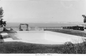
The property was quite different then, we used to swim in the large swimming pool to the west of the main building, the sulphur smell was awful. Today you can still see the row of tile along the north (ocean) edge and, as I recall, the pool was simply filled in in the mid-50s on order of the insurance company, who decided that since we were not Baptists, we wouldn’t need it, it’s still there!
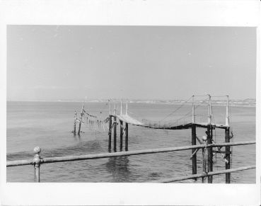
In 1954 my father took me fishing on the wood and canvas pier sticking out below the patio about 200 feet into the Bay. My mother went to her grave never knowing, she would not have been happy. At that time only the two spans closest to the bluff were still standing. At low tide you can still see the remains of the pilings. I can also personally attest that there are tunnels under that building, put to every nefarious use that a kid can think of.
3405 Via Palomino
This stately mansion was built in 1937 by opthalmologist Dr Dennis Vincent and Hazel Littlefield Smith. Prior to WW 2 they had been missionaries in China. When the Japanese began making China uncomfortable they left, came to Palos Verdes, and built 3405 Via Palomino. This is the same Dennis Smith after whom Dennis Smith Hall at Neighborhood Church is named.
The Palos Verdes Project had been in financial straits during the Depression so land was pretty cheap, and the Smiths bought 10 lots around the house (which sits on two) including what is now 3401 and several across the street. In fact, 3401 was the back yard.
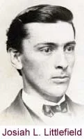
Mrs Smith’s father, Josiah Littlefield, Civil War veteran and Michigan lumber baron (have you heard of the Grand Trunk Railroad? He built it originally to get logs down to the Detroit River), had owned a house in tiny Farwell, MI (population 250), across from which lived my mother’s family.

Hi Dana Graham I just finished reading your article on “Things You Always Woundered About Palos Verdes”. It was great and it brought back alot of my own memories of growing up there in the Valmonte area. My parents bought a home on Via Pavion in the fall of 1952 when I was 10 years old. At that time there were only 4 or so homes on whole street. I don’t recall if we knew each other, because Iam a liitle older. I graduated from Narbonne in 1960. But I had some good friends on Via Pinzon Dennis Schmitz, Ed Buckner and Dennis Madden. Those were high school buddies. Sincerly Doug Cunningham
Doug: Great to hear from you. Were you on Pavion over by Dr Kiebler (3900), or on the east end? I knew the Schmitz’s very well and hung out with Jimmy, had encouters with Leslie, but Dennis was much older . I’m sure you know that he passed away a couple of years ago. I hadn’t seen him from about 1960 until about 8 years ago when he helped his son buy one of my listings on Via Solano (the Putnam’s — daughter Janet would be about your age). Last I heard, Fidel Schmitz was still kicking. Didn’t know Ed Buckner, tho the name sounds slightly familiar. Didn’t know Dennis Madden. I hung out with John Harrington, Paul Shirk, Allan and John Lind, Jim Schmitz, Mike Humm, and Mike Ernaga, all of whom pretty much lived on Pinzon. You might have known Carl Creal on Hawthorne (now Valmonte) — killed in Viet Nam. Remember Julian that ran the stables? We must have bugged the heck out of him. Anyway, it’s always great to hear from anyone from the old neighborhood.
Dana,
My parents bought a lot in 1956 from a work friend at United Airlines who lived on Via Pinzon (across from the Carveys?). It was a parcel to the rear of his home and became the first house on lower Via Pavion. (4409) We arranged for utilities to be extended and the street to be paved. It used to be the access road to the dicalite mine. We soon had neighbors but it was many years before all the lots sold. You may remember my sister Charlotte (PVHS class of ’64) and my brother Don, (class of ’67) I was class of ’71 and my little sister Andrea was class of ’77. I am Jay Morrison and really enjoy reading history of my beloved home town. Thanks.